About the Project

Corridor Overview
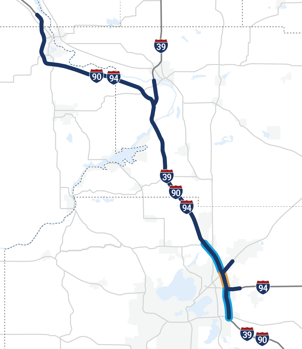
I-39/90/94 is part of Wisconsin’s “backbone system," a network of multi-lane highways connecting all major population and economic regions of the state. The I-39/90/94 Corridor is of vital importance to the region, the state and the nation and is relied on for its freight mobility, tourism and employment access.
The project corridor is 67 miles long and includes the longest stretch of three concurrent Interstates (29 miles) in the country.
Proposed Improvements
The I-39/90/94 Corridor Project will add a general-purpose lane in each direction along the present freeway alignment throughout a majority of the project corridor. I-39 from where it splits from I-90/94 to Levee Road will be reconstructed with the same number of lanes as the existing freeway.
Collector-distributor lanes will be added from WIS 30 to US 151 between the I-94/WIS 30 and US 151/High Crossing Boulevard Interchanges.
Auxiliary lanes will be added between the US 12/18 and I-94/WIS 30 Interchanges and at certain locations between the US 151 and WIS 19 Interchanges.
The project will also include improvements to 15 existing interchanges and the potential addition of two new interchanges. Use the interactive project map below to learn more about the interchange improvements.
interchanges
interchanges
removed
Interactive Project Map
Corridor Updates
PDF of Project Corridor MapSelect a location ⬤ on the map below or a location name from the dropdown list ▼ to learn more about travel or construction updates happening along the project corridor.
Select a location name from the dropdown list ▼ to learn more about travel or construction updates happening along the project corridor.
Hoepker Road is an overpass on I-39/90/94. The city of Madison requested WisDOT evaluate an interchange at Hoepker Road, which would provide access to ongoing business and residential development, including the American Family campus and UW Health hospital. A shifted diamond interchange could be constructed depending upon a funding agreement with the city of Madison. The freeway would be shifted to the east to allow enough room for the southbound ramps on the west side of the freeway.
Milwaukee Street dead-ends near East Hill Parkway and does not cross I-94. The city of Madison requested WisDOT evaluate a potential interchange in this location. A partial cloverleaf interchange could be constructed depending upon a funding agreement with the city of Madison. The potential new interchange would provide needed access for area residents who currently have a long trip to reach an Interstate interchange.
Purpose and Need Summary
The purpose of the I-39/90/94 Corridor Project is to address existing and future traffic demands, safety issues, aging and outdated infrastructure, and corridor resiliency.
The need for the transportation improvements in the I-39/90/94 corridor is demonstrated through a combination of factors including the following elements:

Needs
Resiliency

Traffic Demands
Roadways are typically designed to accommodate traffic volumes projected to occur 20 years in the future. Level of Service (LOS) is the measure of a roadway’s congestion. Sections of I-39/90/94 will operate at unacceptable Levels of Service by 2034, and most of the corridor will operate unacceptably by 2050 in the absence of improvements.

Safety Needs
The I-39/90/94 South Section (between US 12/18 and WIS 60) crash rates exceeded the statewide average crash rate at interchanges. The North Section (between WIS 60 and US 12/ WIS 16, and I-39 from the I-39 I-90/94 Split to Levee Road) has crash rates along portions of the mainline at or higher than the statewide average. Crash rates at two of the interchanges (WIS 13 and US 12) are twice the statewide average.

Bridge Conditions
Within the I-39/90/94 corridor, there are 113 bridges, of which 84 will be over 50 years old in the year 2030. Further, many bridges do not meet current standards for bridge height or width clearances.

Pavement Condition
Pavement maintenance projects in the I-39/90/94 corridor are anticipated in 24 of the next 30 years somewhere in the corridor, which presents ongoing travel delay and congestion for daily commercial and recreational traffic. Eventually, full pavement replacement is more cost effective than more repair.

Corridor Resiliency
Flood events causing partial or full Interstate closures since 2008 have impacted vital connections for commerce and emergency services. Both I-39 and I-90/94 are in a low area as they cross the Baraboo and Wisconsin Rivers. The Baraboo River flooding is problematic because it affects both I-90/94 and I-39, which has substantial impacts to both state and national commerce.